
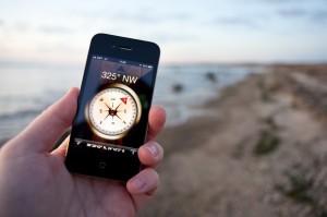
A digital map, on the other hand, can be zoomed in on to reveal names of roads, and an icon will indicate the user’s location. GPS technology, though only having been in common use in the last decade, has been around in primitive form since the 1980s. It was invented for use by the US Department of Defense, and today is powered by 24 satellites orbiting the Earth. Early car-based models debuted in the mid- and late 1990s, and were expensive and not always accurate. It was not until the early 2000s that car-based satellite navigation became common and affordable. In the last few years, they have become a standard feature of new cars, and the technology is readily available in handheld devices and on smartphones. People use it to get around, as well as for games such as geocaching. The question that many ask today is whether digital maps and GPS navigation have made paper maps obsolete. The digital technology is certainly more convenient. However, the dependency of the modern world on GPS technology can be compared to reliance on calculators: it is so easy to push a few buttons for an answer that it takes a conscious effort to maintain maths skills. With GPS technology, the user is shown a charted direction and guided straight to the destination. It requires no map reading, orientation by analyzing surroundings, or asking directions.
However, what happens when the device suffers a technical fault, the battery dies, or the signal disappears? If the user is stranded, they will have to resort to a traditional map stashed in the glove box, or ask someone to point them in the right direction. If out hiking in wilderness, the user could do best to have the GPS as well as a paper map, as a handheld GPS, with its tiny screen, will not give them a good picture of the wider area. In this way, the paper map steps in where the technology fails. Unless technology becomes so advanced that it is foolproof, it will never be a complete replacement for a paper map. The paper map is a safety net, an old friend to turn to when things go wrong, and a challenge to keep personal orientation skills strong.


7 comments
2 pings
Skip to comment form
The GPS is wonderful and I use one often to mark fishing hot spots, entrances to hidden lakes from the river, and various other things. However, the GPS will never replace having the ability to read a map, interpret a topographic map, and navigate with nothing more than a map and compass. Most people find reading a map difficult for some reason and for most it is the fact that they do not practice reading a map and rely on a GPS too much. Since the GPS is an electronic device it will fail and even when using a GPS, everyone should have a paper map on hand for when it does.
Author
Great points, and map reading skills do not ONLY apply to military topo maps. By simply knowing how to properly orient a map and correlate using man made features, one can accomplish quite a bit with a regular road map.
terrain association is by far the best land navigation skill to have. and it is self correcting! as long as you arent in the desert…
Author
Terrain Association has saved my butt a few times. There was one time however when it did not help, you probably know the time I am referring to. I would equate that to an attempt at orienteering while on the surface of the moon in pitch black darkness. Utterly impossible…
Good point on desert navigation but in a true survival situation in the desert you should navigate with the stars at night. Of course that form of navigation is pretty much a lost art.
Author
Hmmm…that’s a great point and something definitely lost on most people (including myself). Maybe you could enlighten us with another expert article! 🙂
i have no idea how to do anything with stars. I am 100% convinced that all of these so-called “constellations” are myths… I have never been able to see any of them. Also this whole north star thing, come on, there is no such thing
[…] a discussion the other day concerning the GPS, I opened my big mouth and mentioned “the proper way to do that would be…”. An additional […]
[…] a discussion the other day concerning the GPS, I opened my big mouth and mentioned “the proper way to do that would be…”. An additional […]